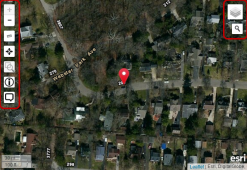
User Activity Viewer
Use the User Activity Viewer to do map-based analysis. The map is interactive:
- Use your mouse to click, pan, and scroll to zoom within the map
- Items on the map are marked with pins. Pins display together at high zoom levels. As you zoom in, pins display individually. Select individual items by clicking on their pins.
- In the top left corner, use the Search By dropdown lists
- In the first Search By dropdown list, click a user
- In the second Search By dropdown list, click a date range or click Custom to enter your own Start Date and End Date
- At the right of the screen, click Refresh to find items matching the user and dates you chose
- The items (represented by pins) that match your user and date range appear on the map. Click an item (pin) to display the form name and Item ID


 )
)
In the upper-left corner of the map, the map tools are in a vertical toolbar:
| Map Tool | Description |
Map Layer Information (  ) ) |
For information about a specific point:
|
Measure Distances (  ) ) |
Click the Ruler icon again to toggle it off |
Show My Current Location (  ) ) |
Click Bullseye (  ) to center the map on your current location as determined by your web browser ) to center the map on your current location as determined by your web browser |
| Zoom In/Zoom Out (+ - ) | Click Plus (+) and Minus (-) to zoom in and out |
Zoom to a Specific Area (  ) ) |
To toggle off, click the icon again |
In the upper-right corner of the map, put the mouse pointer on the Layer Picker ( ![]() ) to see the map layers (Street, Satellite, Hybrid) you can display on the map. If your company uses custom Map Layers, these are also in the Layer Picker (see System Management (
) to see the map layers (Street, Satellite, Hybrid) you can display on the map. If your company uses custom Map Layers, these are also in the Layer Picker (see System Management ( ![]() ) > Administration tab > General >Map Layers)
) > Administration tab > General >Map Layers)
| Layer Information | Description |
| Facility Location | A facility location is the geographical location of the asset or facility you are trying to protect. Facility locations are defined when you add map definitions. If you indicate that facilities are not in use, they appear differently on the map. Facility locations can be processed by auto processing rules (Auto Response) |
| ESRI Hybrid | A base layer that shows streets, photographic landscape, and political borders (state, province, nation) |
| ESRI (Sat) | A base layer that shows photographic landscape |
| ESRI (Street) | A base layer that shows only roads, streets, highways |
| irth GIS | A base layer that shows streets and political borders (state, province, nation) |
| Parcels | Shows all parcel boundaries on the three most detailed (zoomed-in ( + )) map views |
|
Responsibility Areas |
A responsibility area is the area in which a person, group of people, or an office is responsible for the work to be done in it. Responsibility areas are defined when you add Map Definitions (If you indicate that responsibility areas are not in use, they appear differently on the map) |
- Click Search (
 )
) - In the search box, type an address (the search is formatted as street, city, state) or latitude/longitude coordinates (type latitude, a space, then longitude)
- Press Enter or click a suggested result to go to it on the map

